Map of the Tel Aviv light rail and metro
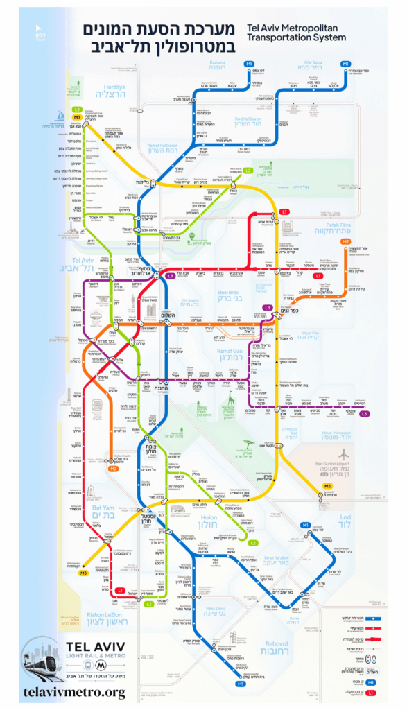
Gush Dan network map — the operational Red Line, 34 of its stations and the future lines. View here or download as a PDF file.
Gush Dan network map
The Gush Dan light rail and metro map: the operational Red Line with 34 stations along 24 km (15 mi), alongside the future lines — the Purple, the Green and the metro lines. Currently only the Red Line is operational.
📄
Download the light rail map as a PDF
A high-resolution file, suitable for printing or saving on your phone for offline viewing.
Lines and status legend
Red Line (Red)HaKomemiyut ↔ Petah Tikva Central Bus Station · 34 stations
OperatingPurple Line (Purple)Tel Aviv (Arlozorov) ↔ Yehud / Tzomet HaTayasim · Opening estimated: 2027 (projected)
Under constructionGreen Line (Green)Rishon LeZion ↔ Herzliya / Ramat HaHayal · Opening estimated: 2028–2030 (projected)
Under constructionMetro Line M1 (Blue)Ra’anana–Herzliya ↔ Rishon LeZion (north–south axis) · Opening estimated: early 2030s (projected)
Under constructionMetro Line M2 (Orange)East Gush Dan ↔ Tel Aviv · In planning — 2030s (projected)
PlannedMetro Line M3 (Yellow)Herzliya ↔ Bat Yam (with a spur to Ben Gurion Airport) · In planning — 2030s (projected)
PlannedRed Line station map
A clickable map of the Red Line in station order, with the terminus stations and the future transfers. Tap a station to open its page. Stations of the additional lines will be added as they open.
Red Line · HaKomemiyut ↔ Petah Tikva Central Bus Station
HaKomemiyutTerminus
CarlebachFuture interchange · Purple Line
ArlozorovFuture interchange · Green Line / Purple Line
Petah Tikva Central Bus StationTerminus